Tracking & Monitoring Module

The Tracking and monitoring module is a full GIS system based on the latest ESRI map engine. It provides real-time view of all assets on a map, separated into layers to provide flexibility in managing and controlling all assets.

The module supports multiple online/offline maps, satellite photos with worldwide coverage. Restricted areas (Geo-fencing) can be added to the map to trigger safety and other alerts. In addition to location, the system provides a range of information regarding the status of the assets like: movement, speed, distress, transmission times, GPS accuracy, and other sensors. The module is accompanied by a sophisticated rule-based engine that triggers alerts and notifications while taking into account asset status, events and geographical location. The module can be used for a range of users ranging from defense and security to operations management.


FEATURES

The module supports online and offline maps. The system enable easy upload of any type of map and scrolling between maps for complete geographical and photographic identification.
The module present on the map and in aggregated view in management area full information on the asset: status, problems, escalations, sensorial information all in a dashboard look and feel.
 

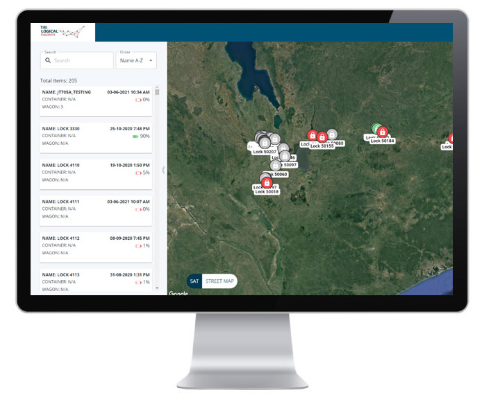
The module has a comprehensive rule based alert engine that enable creating alerts according the customer needs taking into account sensor info, geographical location, assets and combination of all. Alerts can be distributed by mail, SMS and reports providing a full visibility of ongoing challenges.

Route planning can be used for multiple purposes. The module provide tools to create pre-defined routs with waypoints. These rouses can be monitored compared against actual route. Deviation from planed route can trigger real-time alerts.
Any asset can be inquired for past information. There is no limit to how far back you can inquire. Full location, speed, sensor info and additional information can be gathered and presents. This is very useful for accident debriefing and training
 
Because each driver needs to identify in order to activate vehicle all his driving history is recorded and can be used for later examination.

Subscribe to our RAILWAY DIGITALIZATION NEWSLETTER